top of page

Blog

Blog Picture.jpg
Search

In 1975, the Area Licensing Scheme (ALS) was unveiled in Singapore - a transport milestone. For the first time in modern Singapore’s history, motorists had to pay to use congested roads; it was the world’s first intra-city cordon-based road-pricing system. Motorists paid a few dollars for daily paper licences to enter the Restricted Zone, which covered the Central Area. Auxiliary policemen had to be posted at gantries to spot vehicles entering the RZ without a valid licence.

An ALS gantry over Bencoolen Street. Credit: National Archives of Singapore.
Eu Tong Sen Street. Credit: National Archives of Singapore.
The junction of Orchard Road and Scotts Road. A warden is looking out for vehicles without valid licences. Credit: National Archives of Singapore.
An area licence, valid only on the printed date. Credit: Singapore Memory Project.

As technology advanced, the system evolved. Twenty-three years later, in 1998, the ALS was replaced by the Electronic Road Pricing (ERP) system, which employed computers, cameras, radio waves, and smart cards slotted into in-vehicle units. ERP removed the need for wardens to look out for vehicles without valid licences; also, the pricing system taxed motorists for each access of a road, instead of granting them unlimited daily access with one licence. The system was also gradually broadened to congested roads and expressways outside the Central Area. My book Jalan Singapura details all these.

An ERP gantry over North Bridge Road. Credit: Mailer_diablo, CC BY-SA 3.0.

Now, the next generation of road pricing is upon us - sort of. By 2023, 25 years after the launch of ERP, it will transition to a satellite-based system, and a million vehicles will have to be installed with new on-board units, with bigger screens displaying maps, traffic information, and safety alerts.


However, plans to convert the tax from a cordon-based system to a distance-based one have been put on hold for now.


“The new ERP system is capable of charging by distance,” he added, “but as a policy we are holding back”.


To sum up, “how ERP works will not change. What will change is that there is no need for big gantries anymore.”


Distance-based charging definitely requires closer study, because it might disadvantage certain groups of motorists, such as those who live in the suburbs but work in the Central Area, taxi and private-hire drivers who have to cruise around for fares or travel to passengers’ pick-up locations, and delivery and transport businesses, to name a few.


There are other kinks to iron out. The new on-board unit, which comprises an antenna, a touchscreen display, and a processing unit, has received criticism for its perceived bulkiness. Also, the card-based mode of payment remains unchanged; I had expected the payment to go cardless, what with the Republic’s Smart Nation Initiative.


Anyway, it is still early days yet; the transition will take three years. Private car owners have been given more than enough notice. Hopefully, the third generation of road pricing will not just properly regulate road usage, it will also persuade more to give up their cars and use public transport instead.

In the 1960s, bus routes could be listed in the newspapers as public service announcements, but not in an infographic or on a map - instead, the stops were named in one long, rambling paragraph, like this listing in 1967:

I wonder how many readers actually made sense of this. Or perhaps it just made sense to the people living or working in the areas mentioned, and that was all that mattered.


It’s a pity that these archaic routes were never accompanied by infographics or maps - the visuals would have been great resources for the study of the geography of transport! For example, the siting of bus stops.


(The Paya Lebar Bus Service was merged with other bus companies in 1971 to form the Associated Bus Services, which merged again with other bus companies in 1973 to form the Singapore Bus Service, the predecessor of SBS Transit today.)


Compare the 1967 listing above with a poster detailing a new bus service, 381, 50 years later:

Credit: Go-Ahead Singapore.

  • Sep 8, 2020
Credit: U/EconomicSanction.

Some of my observations:


1. Many planned Light Rapid Transit (LRT) lines did not materialise. There were plans for lines in Jurong (even running to Jurong Island), Tuas, Sembawang and Yishun, Bedok, and an arc running from Marina East to Labrador Park - all these never happened. I doubt they will, considering how the bumbling Bukit Panjang LRT Line has been both expensive and problematic since it opened in 1999. If precious money is to be spent on rail lines, might as well build MRT lines to serve as many people as possible. History has shown that wherever an MRT line opens, the volumes of commuter crowds usually follow.

The troubled Bukit Panjang LRT Line. Credit: Mailer_diablo, CC BY-SA 3.0.

2. Major MRT lines planned in 2001 which never happened: A northern line (in light green) running from Sembawang to Changi Airport; a northeastern line (in pink) running from Seletar to future reclaimed land south of Marine Parade and East Coast Park; a southwestern line (in light red) running from Somerset to Jurong. I’ve recommended building variations of these lines in my book Jalan Singapura - these would collectively be a vast improvement to islandwide public transport connectivity.


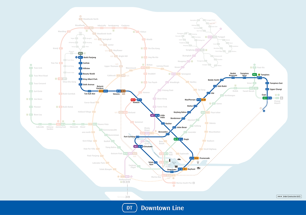
3. The future Downtown Line extension to Sungei Kadut is similar to what had been planned in 2001, except that 2001 suggested the extension be lengthened northward to Woodlands. I’ve always thought such an extension, covering the ageing neighbourhood of Marsiling and ending at Woodlands MRT Interchange, should be considered. It makes sense to complete the loop, so to speak, and the extension would greatly benefit people living and working in the north.

The junction of Admiralty Road and Marsiling Drive - part of Marsiling, the oldest part of Woodlands town. Credit: Google Maps.

4. It’s good that a planned LRT line for Jurong has been upsized to the Jurong Region Line, which also connects Choa Chu Kang and Bukit Batok. But considering the geographical vastness and size of the population of the Tuas-Jurong region, I still feel a new MRT line is needed to connect the whole area to the City, at least to relieve pressure on the ageing East West Line. I have also suggested this in Jalan Singapura.


5. 2001’s Bukit Timah Line was merged with the Eastern Region Line to create the present Downtown Line; the Thomson Line was merged with an East Coast line to get the present Thomson-East Coast Line. Merging planned lines is good - this reduces the number of transfers needed. Commuters generally prefer direct routes and fewer transfers.

The Downtown Line. Credit: Land Transport Authority.

6. It’s distressing to be reminded that the Circle Line of 2001 was subsequently rerouted to cover the Bukit Brown area. Future development of the entire historic region still remains very much on the cards.


7. I wonder if the planned reclamation of islands south of Marine Parade and East Coast Park would ever materialise. Sounds like an attractive notion, creating lots of land for seafront housing and recreation which could then free up space elsewhere, although I think the residents of Marine Parade and East Coast Road-Upper East Coast Road would violently object to having their coastline retreat from them!

Marine Parade Estate nearing completion in the 1970s. Credit: Housing and Development Board.

Copyright © 2025 Eisen Teo. Proudly created with Wix.com

bottom of page