top of page

Blog

Eisen Teo's blog has research and thoughts on history, transport, and urban studies,  and snippets of life experiences.
Search

In May 2021, I blogged about my endeavour to retrace the easternmost portion of the Jurong Railway Line from its origin near Bukit Timah Railway Station to the Clementi Road Railway Tunnel. 


In December 2022, I continued this retracing, covering the railway line west from Clementi Road. 


I then archived the photos and videos until recent news broke of Maju Forest's impending demise.


As a significant portion of the Jurong Railway Line runs through the Maju Forest, I am now blogging about my 2022 exploration to put on record my journey and observations.


In my previous post about the Jurong Railway Line, I mentioned my interest in searching for the footnotes of history. These footnotes, on the periphery of physical and mental spaces, are frequently under threat of obliteration. This is a real possibility for the Jurong Railway Line inside Maju Forest.


Part I: Crossing Maju Forest


Back in December 2022, I travelled once again to Bus Stop 12089 opposite Maju Camp, the same start point as my exploration of Clementi Forest (Point A in the map below).

Base picture credit: Google Maps.


I descended the slope into the railway tunnel. 


While I headed east into Clementi Forest in 2021, this time, I headed west into Maju Forest, named after Maju Camp. 


I was immediately reminded that the railway track was laid on a cutting carved out of the terrain – the sides of the track were flooded by stagnant water thick with mud. The afternoon air was still and heavy with jungle humidity. 


The first part of the track in Maju Forest heading west was relatively easy to traverse, despite the dense undergrowth and the occasional fallen tree. 


Decades of abandonment meant trees were also growing over the track. 


All around me, trees towered up to four storeys above me.


Slightly more than 200 metres inside the forest, at roughly this location (below), I received a rude shock – I suddenly came face-to-face with a huge wild boar!

This specimen was higher than my waist level in height, and was only a few metres from me. I froze for a split second, then turned tail and clambered through the undergrowth in the opposite direction as fast as I could. I had to return to where I had started as there were steep, forest-covered slopes on both sides. 


Thankfully, the boar did not choose to chase after me. I climbed up the slope behind Bus Stop 12089 and waited until the boar passed by. Below is a still from a video I took of the boar waddling east into Clementi Forest:


I continued waiting for a few minutes until I was sure the coast was clear, before reentering the forest. 


Around 300 metres in, the ground started becoming wetter and muddier...


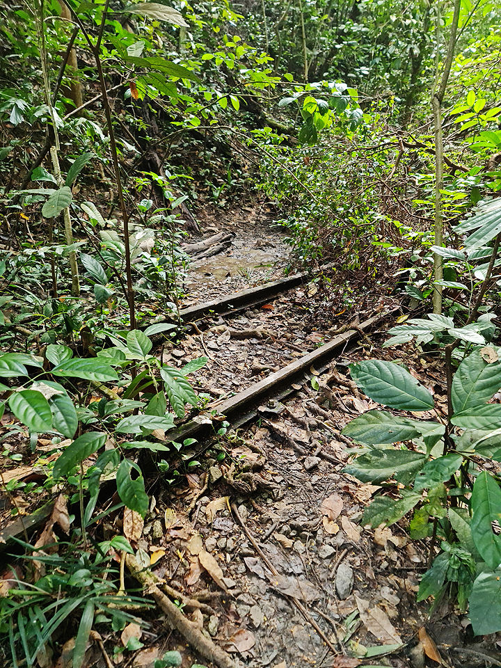
... and the track gradually disappeared below mud and dense undergrowth. 


Part of the track reappeared above the thick mud for a short while...


... then disappeared again.  Heavy-duty hiking boots needed here!


I was at Point B below.

Base picture credit: Google Maps.


From here on, I had to clamber onto higher ground next to the track, and head west-south-west, following what I knew was the historical alignment of the track. Fortunately, like when I was in Clementi Forest, the alternate path next to the buried track was relatively easy to traverse, and it closely hugged the track the whole way.


The track only reappeared a short distance before the Sunset Way Railway Bridge. 


I had reached Point C below.

Base picture credit: Google Maps.


Part II: Two railway bridges


The Sunset Way Railway Bridge itself was closed, but it was easy to cross Sunset Way (below) and head up the other side. 


A view of the track facing Maju Forest.


The track continued west-south-west until it reached the Sungei Ulu Pandan Railway Bridge, which was also closed. 


The Sungei Ulu Pandan Railway Bridge.


A view of the track atop the bridge from behind the barrier.


The complete map of my westward route from the Clementi Road Railway Tunnel to the Sungei Ulu Pandan Bridge.

Base picture credit: Google Maps.


This time, meeting up with the track on the other side required a longer detour. I had to head southeast along the park connector to a covered linkway over the river, cross over, then head northwest back to the track.


Part III: The Clementi Avenue 4 glade


The track continued along a quiet, delightful glade between the Clementi Avenue 4 blocks and the Sungei Ulu Pandan. 


Not a common sight – the track running across a foot path.


A short distance after running under a flyover carrying Clementi Avenue 6 over the Sungei Ulu Pandan, the track abruptly ends before Clementi NorthArc, which was under construction at the time, but was completed in early 2023.


And herein concludes the second leg of my exploration of the Jurong Railway Line. 

Base picture credit: Google Maps.


There is a possibility that the Jurong Railway Line inside Maju Forest could be conserved as part of a nature trail next to the planned housing estate, but there is no guarantee of this happening. 


I hope a greater portion of the Maju Forest can be conserved alongside Clementi Forest as irreplaceable green lungs and heritage ecosystems in Singapore’s southwest.


What is the easternmost road on Singapore Island?

Over 200 years of modern Singapore’s history, the answer has changed a number of times, because of waves of land reclamation, and infrastructural development at the eastern end of the island.


***


The British founded modern Singapore in 1819. From the 1840s, country roads began to be built from the Town - occupying an area roughly three miles by one mile in the southeastern corner of the island, around the Singapore River - to various corners of the island. One such road snaked from the eastern end of the Town, crossing the Sungei Kallang, across the eastern part of the island, to Sungei Changi at the eastern end, 15 miles away.


As the road passed the Sungei Changi, itself named after the chengal tree, the road was named Changi Road. It was completed sometime between 1843 and 1845, and became Singapore’s easternmost road.

A Chengal tree in Malaysia. “Chengal tree, Peninsula Malaysia, 2005” by Christoph Swoboda is licensed under CC BY-SA 3.0.

Below is an 1846 map showing Changi Road ending around the Sungei Changi in the east of the island.

Credit: Urban Redevelopment Authority.

A Changi Bus Company bus on the 13½ Milestone of Changi Road, about a mile from the Sungei Changi, 1953. Credit: F W York Collection, courtesy of National Archives of Singapore.

With the road came settlers to the area around Sungei Changi, although it is also possible that settlers arrived by sea. By the start of the 20th century, two villages arose along the coast off the 13th and 14th Milestones - Kampong Telok Paku and Kampong Beting Kusah. Telok Paku is Malay for “Bay of Nails”, while Beting Kusah is Malay for “Troubled Shoal” - possibly hinting at the dangerous waters off the coast.

The beach at Telok Paku, 1954. Credit: Donald Moore Collection, courtesy of National Archives of Singapore.

The beach at Telok Paku, 1955. Credit: Donald Moore Collection, courtesy of National Archives of Singapore.

Below is a 1923 map showing two tracks connecting the kampungs to Changi Road - Telok Paku Road and Beting Kusah Road. A footpath ran north from Telok Paku Road, hugging the coastline, making Telok Paku Road Singapore’s easternmost road.

Credit: The National Archives, United Kingdom.

During the Japanese Occupation, the Japanese forced Allied prisoners-of-war to start work on an airfield in the area, building two landing strips intersecting in a cross. After the Japanese surrendered in 1945, they were made to complete the airfield, and it opened as Changi Airfield the following year.


The airfield was laid down over parts of Telok Paku Road and Beting Kusah Road, and the shorter, horizontal landing strip forced the realignment of Beting Kusah Road to the east, closer to the coast. However, it still fell short of Telok Paku Road, which remained Singapore’s easternmost road.


Below is a 1945 map showing Telok Paku Road in blue, and Beting Kusah Road in yellow.

Credit: Survey Department, Singapore.

Telok Paku Road, 1942. Credit: The National Archives, United Kingdom.

Telok Paku Road, 1956. Credit: F W York Collection, courtesy of National Archives of Singapore.

Telok Paku Road finally relinquished its title close to a decade later in 1955, when Nicoll Drive was completed as the new road hugging the Changi coast, running from the mouth of Sungei Changi to Tanah Merah Besar Road.


For years, there had been calls for such a road to serve the bungalows lining the coast. Nicoll Drive was built over parts of Telok Paku Road and Beting Kusah Road, and it was named after Singapore Governor Sir John Nicoll (below). He also gave his name to Nicoll Highway, many miles away in the City.

Credit: Lok Wan Tho Collection, courtesy of National Archives of Singapore.

Below is a 1955 street directory map showing the realigned Telok Paku Road in blue, and Nicoll Drive in green.


The seawall next to Nicoll Drive to the far left, 1956. Credit: Public Works Department Collection, courtesy of National Archives of Singapore.

Nicoll Drive was Singapore’s easternmost road until the late 1970s, when major land reclamation pushed the island’s eastern coast eastward for the construction of Changi Airport. The new coastal road serving the reclaimed land was Changi Coast Road, which officially opened in 1981.


Below is a 1981 street directory map showing the realigned Telok Paku Road in blue, what was left of Nicoll Drive in green, and Changi Coast Road in yellow. The kampungs of Telok Paku and Beting Kusah, and the seaside bungalows along the idyllic beach served by Nicoll Drive, became distant memories.

One drove along Changi Coast Road to get a good glimpse of Changi Airport and its control tower (below, in 1990).

Credit: Singapore Tourist Promotion Board Collection, courtesy of National Archives of Singapore.

From the 1990s into the 2000s, more reclamation took place in phases to the east of Changi Coast Road, creating a massive, 1,545-hectare block of land called Changi East. By 1995, Changi Coast Road became a misnomer - the coast had retreated far from it.


By 2001, Changi Naval Base was completed at the southeastern corner of the reclaimed land. The road serving it, accessible from Changi Coast Road, was Tanah Merah Coast Road - which then became Singapore’s easternmost road.


Between 2009 and 2017, Aviation Park Road became Singapore’s easternmost road instead, as it was built in the northern part of Changi East to serve Changi Exhibition Centre.


Below is a 2009 street directory map showing Changi Coast Road in yellow, Tanah Merah Coast Road in blue, and Aviation Park Road in green.

By 2017, Tanah Merah Coast Road was extended from south to north to meet Aviation Park Road, covering the eastern coast of Changi East, consequently becoming Singapore’s easternmost road again.


With the completion of the extension of Tanah Merah Coast Road, most of Changi Coast Road - save for a short stretch between Nicoll Drive and Aviation Park Road - was closed and expunged for the building of Changi Airport Terminal 5 (below).

Credit: Land Transport Authority.

Today, Tanah Merah Coast Road remains Singapore’s easternmost road. It is also the only public road in Singapore with a dedicated on-road bicycle lane (below).

Credit: Google Maps.

The current coastline at Changi East is miles away from the original coastline of the 19th century. And, it is set to move further east in coming years, away from Tanah Merah Coast Road.


It has been announced that reclamation of around 900 hectares of land will start by the end of this year, to the east of Changi East (below). The project will take at least 10 years to complete.

Credit: SPH Media Trust.

It remains to be seen what the land will be used for. Likewise, it remains to be seen whether Tanah Merah Coast Road will be realigned to hug the new coastline, or a new coastal road will take its place as Singapore’s easternmost road.

Telok Paku Road today, at the junction of Changi Village Road (formerly part of Changi Road). Credit: Google Maps.

 
  • Jul 23, 2022

Last month, I said goodbye to a bookshop in Bras Basah Complex, which was closing down after 41 years.


Now, another shop in Katong is set to cease operations after almost seven decades: Katong News Agency at 350 Tanjong Katong Road.


Katong News Agency, which opened in 1955, is shutting down after 67 years in business.


The 1,386 sq ft, two-storey shophouse was sold for $4.2 million, or at $3,029 per sq ft, in December.


The last day of business will be Aug 31, said owner Mr Abdul Samad, 66.


People familiar with Tanjong Katong will remember how the shop on 350 Tanjong Katong Road was once popular with parents and students for its extensive range of school textbooks, assessment books, novels, magazines and stationery.


During the December school holidays, Katong News Agency would be bustling with parents snapping up textbooks and stationery for their children for the new school term.


Often, the shop stayed open till late into the night, sometimes closing at midnight, recalled Mr Samad.


His father, Mr Abdul Salam, came from India and started Katong News Agency.


In the beginning, it was a general provision shop selling groceries, cosmetics and books.


In the 1960s, when Tanjong Katong Girls’ School, which is located directly opposite the shop, started holding classes in the evenings, Mr Salam saw the opportunity to sell textbooks to those attending the night classes, said Mr Samad.


Gradually, Mr Salam switched to selling books to cater to students in nearby schools.


Mr Samad said his father was paying rent of $100 a month until 1972, when he bought over the freehold unit for under $300,000.


The iconic shop had catered to generations of students from nearby schools, including Tanjong Katong Girls’ School, Tanjong Katong Technical School, Dunman High School and Chung Cheng High School (Main), in the 1960s to 1990s.


Business plunged when three of the schools moved out of Tanjong Katong Road in the late 1990s.


In 2001, Katong News Agency stopped selling textbooks and was converted into a minimart selling household items, snacks, stationery and toys. By then, Mr Salam had already left the business in the care of his three children.


“During the good times, parents who lived in other parts of Singapore would also travel here to get the assessment books for their children,” recalled Mr Samad, who started running the store in 2006.


“I am very sad to retire. I have been running the store seven days a week since I took over the business. My customers are all very nice. Some of them who had moved out of the area would still return to visit the shop,” he added.


***


Pastries and snacks on sale outside Katong News Agency.

Entering Katong News Agency.

I took a closer look at the old floor tiles.

The adorable handmade signs with a dozen fonts!

The front counter.

For printing services, the shop had an old photocopying machine, with an ancient laptop on it.

The interior of the shop. Some shelves were already empty, as the shop begins to wind down.


The stationery shelf brought me back to childhood visits to bookshops.

Old-school wooden rulers - they made for painful palm slaps.

As expected, there were random items in random corners.

The little touches made all the difference - such as the handwritten price labels.


More memories of my childhood - the cheap tabletop games such as Ludo and checkers.

The last day of Katong News Agency is 31 August.

 
bottom of page