top of page

Blog

Eisen Teo's blog has research and thoughts on history, transport, and urban studies,  and snippets of life experiences.
Search

In May 2021, I blogged about my endeavour to retrace the easternmost portion of the Jurong Railway Line from its origin near Bukit Timah Railway Station to the Clementi Road Railway Tunnel. 


In December 2022, I continued this retracing, covering the railway line west from Clementi Road. 


I then archived the photos and videos until recent news broke of Maju Forest's impending demise.


As a significant portion of the Jurong Railway Line runs through the Maju Forest, I am now blogging about my 2022 exploration to put on record my journey and observations.


In my previous post about the Jurong Railway Line, I mentioned my interest in searching for the footnotes of history. These footnotes, on the periphery of physical and mental spaces, are frequently under threat of obliteration. This is a real possibility for the Jurong Railway Line inside Maju Forest.


Part I: Crossing Maju Forest


Back in December 2022, I travelled once again to Bus Stop 12089 opposite Maju Camp, the same start point as my exploration of Clementi Forest (Point A in the map below).

Base picture credit: Google Maps.


I descended the slope into the railway tunnel. 


While I headed east into Clementi Forest in 2021, this time, I headed west into Maju Forest, named after Maju Camp. 


I was immediately reminded that the railway track was laid on a cutting carved out of the terrain – the sides of the track were flooded by stagnant water thick with mud. The afternoon air was still and heavy with jungle humidity. 


The first part of the track in Maju Forest heading west was relatively easy to traverse, despite the dense undergrowth and the occasional fallen tree. 


Decades of abandonment meant trees were also growing over the track. 


All around me, trees towered up to four storeys above me.


Slightly more than 200 metres inside the forest, at roughly this location (below), I received a rude shock – I suddenly came face-to-face with a huge wild boar!

This specimen was higher than my waist level in height, and was only a few metres from me. I froze for a split second, then turned tail and clambered through the undergrowth in the opposite direction as fast as I could. I had to return to where I had started as there were steep, forest-covered slopes on both sides. 


Thankfully, the boar did not choose to chase after me. I climbed up the slope behind Bus Stop 12089 and waited until the boar passed by. Below is a still from a video I took of the boar waddling east into Clementi Forest:


I continued waiting for a few minutes until I was sure the coast was clear, before reentering the forest. 


Around 300 metres in, the ground started becoming wetter and muddier...


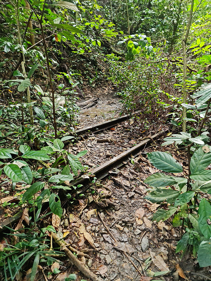
... and the track gradually disappeared below mud and dense undergrowth. 


Part of the track reappeared above the thick mud for a short while...


... then disappeared again.  Heavy-duty hiking boots needed here!


I was at Point B below.

Base picture credit: Google Maps.


From here on, I had to clamber onto higher ground next to the track, and head west-south-west, following what I knew was the historical alignment of the track. Fortunately, like when I was in Clementi Forest, the alternate path next to the buried track was relatively easy to traverse, and it closely hugged the track the whole way.


The track only reappeared a short distance before the Sunset Way Railway Bridge. 


I had reached Point C below.

Base picture credit: Google Maps.


Part II: Two railway bridges


The Sunset Way Railway Bridge itself was closed, but it was easy to cross Sunset Way (below) and head up the other side. 


A view of the track facing Maju Forest.


The track continued west-south-west until it reached the Sungei Ulu Pandan Railway Bridge, which was also closed. 


The Sungei Ulu Pandan Railway Bridge.


A view of the track atop the bridge from behind the barrier.


The complete map of my westward route from the Clementi Road Railway Tunnel to the Sungei Ulu Pandan Bridge.

Base picture credit: Google Maps.


This time, meeting up with the track on the other side required a longer detour. I had to head southeast along the park connector to a covered linkway over the river, cross over, then head northwest back to the track.


Part III: The Clementi Avenue 4 glade


The track continued along a quiet, delightful glade between the Clementi Avenue 4 blocks and the Sungei Ulu Pandan. 


Not a common sight – the track running across a foot path.


A short distance after running under a flyover carrying Clementi Avenue 6 over the Sungei Ulu Pandan, the track abruptly ends before Clementi NorthArc, which was under construction at the time, but was completed in early 2023.


And herein concludes the second leg of my exploration of the Jurong Railway Line. 

Base picture credit: Google Maps.


There is a possibility that the Jurong Railway Line inside Maju Forest could be conserved as part of a nature trail next to the planned housing estate, but there is no guarantee of this happening. 


I hope a greater portion of the Maju Forest can be conserved alongside Clementi Forest as irreplaceable green lungs and heritage ecosystems in Singapore’s southwest.


On the evening of Friday 12 May, as part of this year’s Singapore HeritageFest, I gave a talk on 200 years of Singapore transport and urban history.

Like previous talks, it drew on material from my book Jalan Singapura: 700 Years of Movement in Singapore. This time, however, I included findings from ongoing research for my next book.


I also introduced audience engagement, inviting them to answer two questions on their mobile phones:


1. What is one enduring memory you have of Singapore land transport, which no longer exists?


Some answers:


- Riding Bendy Buses in eastern Singapore

The Bendy Bus used to run in Tampines as part of Bus Service 67. Credit: Shankar S.

- The “ding dong” speed limit warning in the old Crown / Cedric taxis


- The train from Tanjong Pagar to Woodlands and beyond

Photo credit: EquatorialSky2.

- The first railway track! In one of the walking tours, I was brought to this underpass near the pinnacle hdb, I was told this was part of the first railway track. That was what led me to do my own reading up on it, and Eisen’s book shed useful insight in this area


- The old non-air-conditioned SBS buses with the sliding windows. If you didn’t close them on time or couldn’t close them when it rained, the rain will fall and collect on the tracks of the sliding windows and dribble onto the seat and onto the floor which I remember was the industrial aluminium flooring with the anti-slip pattern


2. What is your biggest wish for Singapore transport / urban development?


Some answers:


- Can eat (on public transport)


- To not further disrupt the nature for more roads and mrt networks


- 24 hour public transport


- magnetic levitation


- Bike path connecting each district


- More diverse rail transit modes like bringing back trams, use of monorails beyond Sentosa, etc…


- A wider variety of bus models please


- Abolishment of “Jaywalking” for more pedestrian friendly streets


- ...I would love to see a museum of transport in Singapore with life size vintage vehicles

I wish Tanjong Pagar Railway Station was converted into Singapore's very own museum of transport. Credit: Alicereneztay.

Hear, hear!


Urban renewal is taking place in Shenton Way and Tanjong Pagar, so I headed to the city to check out the buildings being torn down or constructed. 


The iconic AXA Tower at 8 Shenton Way was completed in 1986, which makes it younger than me (!), but has been doomed to redevelopment.


At the junction of Shenton Way and Prince Edward Road.


Looking up at the junction of Shenton Way and Straits Boulevard.


The 52-storey skyscraper once housed the offices of the Ministry of Finance as The Treasury. 


It will make way for Skywaters Residences, a private residential complex which will become Singapore’s tallest building, at 63 storeys and 1,000 feet in height, when it is completed in 2028.


Tanjong Pagar is a short walk away from Shenton Way. In the area between Cantonment Road in the west and Anson Road in the east, there are no fewer than five construction sites. The air hangs heavy with clouds of dust and the cacophony of drilling and pounding. My heart goes out to the residents of nearby Tanjong Pagar Plaza, who will have to endure this for years, with little to no benefit to them.


Below is a map of the five construction sites, coloured blue.


Base map credit: Singapore Land Authority.

1. Keppel Towers at 10 Hoe Chiang Road, a 27-storey building launched in 1991, and Keppel Towers 2 at 240 Tanjong Pagar Road, formerly known as GE Tower, a 13-storey building completed in 1993, have been torn down for Keppel South Central, a 33-storey, energy-efficient commercial tower with a community plaza. Keppel South Central should be ready late next year.


A Straits Times report on the launch of Keppel Towers in August 1991. Credit: SPH Media Trust.

2. Tower Fifteen at 15 Hoe Chiang Road, formerly known as Euro-Asia Centre, at 29 storeys, has been demolished. Fragrance Group had applied to the Urban Redevelopment Authority (URA) for change of use for the site to full hotel usage, so a new hotel should rise on the spot. 


Tower Fifteen, sometime before 2003. Credit: Robert J Steiner.

3. Up to the 1980s, Bernam Street was nearly perpendicular to Anson Road. Between 1984 and 1986, it was realigned to run straight onto Lim Teck Kim Road. The realignment created an open field which laid fallow for more than three decades until recently, when work started on One Bernam, named after its address, 1 Bernam Street, a 34-storey luxury condominium tower to be completed by 2026.


Bernam Street in the 1984 street directory.
A realigned Bernam Street in the 1988 street directory.

4. Realty Centre, an 11-storey building at 15 Enggor Street first advertised in The Straits Times in 1970, was sold in 2019, and demolished after 2021. Its buyer The Place Holdings has obtained provisional permission from URA for a 37-storey mixed-use complex with a two-storey commercial podium and a 33-storey residential tower.


Realty Centre in July 2021.

5. Fuji Xerox Towers at 80 Anson Road, formerly known as IBM Towers, a 38-storey tower completed in 1987, is being demolished for Newport Plaza, a 47-storey mixed-use complex to be ready by 2027.


A Straits Times advertisement for IBM Towers as it neared completion in June 1986. Credit: SPH Media Trust.

Fuji Xerox Towers in July 2021.

The best view of the Tanjong Pagar construction sites is from the top floor of Block 1 Tanjong Pagar Plaza, as the common corridors open up to the south.


This is the southwest view of the sites for Keppel South Central and 15 Hoe Chiang Road.


This is the southeast view of the sites for One Bernam and 15 Enggor Street, and towering above them, Fuji Xerox Towers being torn down. The foreground will gradually rise while the background will slowly disappear.


I will be back in a year’s time.

 
bottom of page