
The last of Boh Sua Tian Road
- Feb 2, 2022
- 8 min read
Updated: Jun 17, 2022
There is a time capsule under the Yio Chu Kang Flyover. It is the remains of a road which used to serve a community long gone. The road was named after a landmark which has also disappeared. Almost everything has vanished, and all that is left is an exhibit of what happens to a road after civilisation is abandoned.

The road is Boh Sua Tian Road, the community is Boh Sua Tian, and they were named after a wireless station. This is their story.
***
Sometime in the 1910s, a Naval Wireless Station was built in the rural northeast of Singapore, along the 9½ Milestone of Yio Chu Kang Road.
This is a map of the area in 1923. The Naval Wireless Station is shaded blue.

At the time, the area was considered “the country”, many miles from the Town of Singapore where most of the population lived. There were vast stretches of rubber plantations to the north and south of the wireless station and Yio Chu Kang Road.
To the west of the station, there were already rural communities farming vegetable gardens, served by tracks with no official names. These communities lay near and along the southern tributaries of the Sungei Seletar. The Chinese living there mainly consisted of Hokkien and Teochew migrants from Fujian, southern China, who had settled at least 20 years earlier, around the turn of the century. Most of them had the surname Toh, with some Neos, Tans, and Seahs. Next to the Sungei Seletar, there was a Malay kampung named Kampong Pengkalan Petai.
Because of the wireless station, the area to its west, up to around the 10th Milestone, where Yio Chu Kang Road abruptly curved to the south, became known as Boh Sua Tian, Hokkien and Teochew for “Wireless”.
This was the area in 1937. The region known as Boh Sua Tian is shaded orange.

The Naval Wireless Station had been renamed Seletar Wireless Station, probably after Royal Air Force (RAF) Seletar, Singapore’s first military airfield which opened in 1928. The wireless station probably served the RAF by then.

Meanwhile, to the west, a community at the 10th Milestone of Yio Chu Kang Road had been officially named Yio Chu Kang Village. Unofficially, though, the area in and around Yio Chu Kang Village, and to its north, was still known to the locals as Boh Sua Tian.
This was the area in 1961. Boh Sua Tian is shaded orange, while the grounds of the wireless station are in blue.

Since the 1920s, as the Municipality of Singapore grew in population, the Land Office and the Singapore Improvement Trust oversaw the clearance of Crown land and the resettlement of its occupants for development. Farmers were usually relocated to rural areas, and given land to continue farming. These became Resettlement Areas. In the 1950s, a Resettlement Area was set up along a tributary of the Sungei Seletar, between Kampong Pengkalan Petai and Yio Chu Kang Road.
The road serving the Resettlement Area was named Boh Sua Tian Road - finally, the authorities acknowledged the local Chinese name. Consequently, the Resettlement Area became known as Boh Sua Tian Village, or Kampong Boh Sua Tian.
Kampong Boh Sua Tian first appeared in the newspapers in 1958. At the time, the Singapore Auxiliary Fire Service planned to teach the villagers fire-fighting methods, a necessity as kampung houses were usually made of flammable wood and attap.

By the end of the 1960s, many tracks in Boh Sua Tian had been officially named. They included Track 14 Yio Chu Kang Road, Lorong Gemilap, Lorong Selangin, and Lorong Hablor. Three tracks east of Boh Sua Tian Road were named Lorong Andong, Lorong Anchak, and Lorong Jirak. Boh Sua Tian was roughly the area bounded by Kampong Pengkalan Petai to the north, Track 14 to the west, Yio Chu Kang Road to the south, and Lorong Jirak to the east.
There was a Boh Sua Tian Community Centre, and three schools serving the area - Nong Chong School, Sin Cheng School, and Kong Hwa School.
This was the area in 1976.

By 1980, there were 600-odd families in Boh Sua Tian. To the north, near the banks of the Sungei Seletar, which soon became Lower Seletar Reservoir, the Singapore Armed Forces held military exercises. Soldiers used Boh Sua Tian Road - a muddy road, no asphalt - to head to their field camps.
They recalled rubber trees, fruit trees, and vegetable farms lining both sides of the road. They helped themselves to the produce of fruit trees - durians, papayas, lemons. They stopped by provision shops to buy cold drinks. Sometimes, for a dollar, the villagers whipped up bee hoon (rice vermicelli) with canned pork for them.
Nong Chong (literally “Farming Village”) School, a one-storey building erected in 1945, had 200 pupils. The canteen was a provision shop on the other side of Track 14. Its shopkeeper set up a little stall for his daughter to sell noodle soup. After school, pupils came to eat noodles, help themselves to the sweetmeats in his shop, or invade his home next door to watch TV.


A 1980 New Nation article tried to capture the essence of the region:
Shrub-lined roads that wind seemingly to nowhere, ponds that glisten like green jewels, brightly-painted zinc and wood houses, vegetables in neat rows, tanned and sinewy farmhands enjoying a brief respite from their labours under a wayside tree…
This is Boh Sua Tian…
It is not advisable to wander around the place on foot - the roads are simply too long; you will need an entire afternoon just getting to Lorong Selangin itself. And there are at least two other side tracks that hold promise of an interesting nature walk.
Don’t take a car either. While all these roads are metalled, in some parts they are so narrow as to be virtual one-way streets. The tracks are also so riddled with potholes as to make car rides uncomfortable.
The best is to follow the villagers and ride a bicycle. I toured the area on my 10-speed racer one morning starting at dawn when I saw groups of pretty girls cycling (sometimes two to a bicycle) out to Yio Chu Kang Road to catch a bus to work.
Morning is also the best time to catch the people outdoors as it is still cool.
Then you will see housewives at the well busy washing clothes while little children run around; perhaps an old man in singlet and shorts sitting under a porch picking his teeth, or a black dog with a red scarf round his neck lolling in the shade of a guava tree.
Or someone spraying weedkiller beside a pond; or a stout woman returning home with a basket of vegetables and meat from the market at the junction of Track 14 and the main road.
Everywhere a placid mood prevails. There is, of course, the staccato crowing of the rooster at the oddest times of the day, the constant chatter of birds, dogs barking in the distance and the occasional shouts of children.
Afternoon is the quietest time: the heat would have driven people and animals to seek shade. But come dusk and the air is filled with the merry voices of people returning from work, the dull roar of cars rumbling back on the uneven roads and the increasingly loud droning of night insects.
And, of course, there is the smell of the country: warm, pungent and homey. The smoke from the kitchen, the repellent odour from the chicken coops and of fresh fertiliser on the soil, the keen fragrance of flowers and bushes soaked in dew.
A 15-minute cycle ride along Lorong Selangin takes you to Boh Sua Tian Road. Turn right and watch out for Lorong Anchak 100 metres away.
There you will find stretches of mirror-smooth ponds fringed with palms, banana trees, sugar cane and shrubs. The scene is like some Chinese landscape painting minus the mountain and mist.
But spend a day at Boh Sua Tian and see for yourself a rural way of life so familiar yet becoming more alien as HDB flats and shopping complexes gradually overwhelm our entire island.
This was a community on its last legs. The following photos were taken in 1986, all courtesy of the National Archives of Singapore.


***
In a few years, Boh Sua Tian met its demise, sharing the same fate of so many rural communities all over Singapore.
Resettlement commenced in the late 1980s - for the farmers of the Resettlement Area, they had to move again after just three decades. Concurrently, construction work for the Seletar Expressway started. Like a knife, the expressway sliced horizontally across Boh Sua Tian and its tracks. The expressway was joined to the Central Expressway via the Yio Chu Kang Flyover, which ran over Yio Chu Kang Road. This part of Seletar Expressway opened in 1990.
The segment of Boh Sua Tian north of Seletar Expressway still required access to the main road, Yio Chu Kang Road. Hence, part of Boh Sua Tian Road was realigned to run under the Yio Chu Kang Flyover and connect to Yio Chu Kang Road.
This was the area in 1988.

This was the area in 1991, after the opening of the Seletar Expressway.

The fates of Boh Sua Tian Road, Lorong Andong, Lorong Anchak, and Lorong Jirak were sealed a few years later in the mid-1990s, when the Tampines Expressway was extended to meet the Seletar Expressway and Central Expressway. The expressway interchange was constructed over these roads; a flyover was named Boh Sua Tian Flyover, but was shortly renamed Seletar Flyover.
The junction of Yio Chu Kang Road and Boh Sua Tian Road was sealed; whatever was left of the road was removed from the street directory. After around 70 years, the place name Boh Sua Tian quietly disappeared into history.
As for Seletar Wireless Station, it was redeveloped into Yio Chu Kang Radio Receiving Station. The station eventually closed, and the complex torn down between 2018 and 2019.
This was Yio Chu Kang Radio Receiving Station before it was demolished. The complex had a couple of intriguing-looking buildings; it’s a pity that nothing was conserved.

Parts of the site are now occupied by Yio Chu Kang Road Heavy Vehicle Park, Seletar West Road 1, and Migrant Worker Onboarding Centre (MWOC) @ Sengkang.
This is the area today.

Much of the former Boh Sua Tian has reverted to forest, and is inaccessible because it remains a live firing area. The key infrastructural development is the expressway system.
***
It is still possible to visit what is left of Boh Sua Tian Road.
Slightly to the west of the junction of Yio Chu Kang Road and Begonia Road, there is a walkway into Yio Chu Kang Road Heavy Vehicle Park.

Yio Chu Kang Road Heavy Vehicle Park.

I walked to the northwestern corner of the heavy vehicle park.

A massive field sprawled before me - this was formerly the grounds of the wireless station which gave Boh Sua Tian its name.

I crossed the field in a northwesterly direction, until I reached MWOC @ Sengkang at the western end of Seletar West Road 1.

I headed west, crossing another field, to the Yio Chu Kang Flyover... and there lay the remains of Boh Sua Tian Road. The wilderness was in the process of swallowing the road.

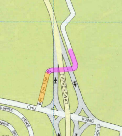
On this 1991 map of Yio Chu Kang Flyover, the parts of Boh Sua Tian Road which have survived are highlighted orange and pink. The orange segment dates to between 1961 and 1970; the pink segment dates to between 1988 and 1991.
Approaching Yio Chu Kang Flyover from the east.

The 4.5m sign is the surest indicator that this was once a road for motor vehicles.

Facing east.

Thirty years of abandonment. Thirty years of exposure to the elements.

Nature always finds a way back.


In the gaps between roadways, vegetation has flourished, adding a verdant splash to the concrete landscape.
It feels odd to be in a deserted garden-like setting while the muffled roars of vehicles echo overhead.

Facing east.

Further west, as the former road curves towards Yio Chu Kang Road, the vegetation grows thicker.

The westernmost stretch of what is left of Boh Sua Tian Road - which is also the oldest, at least 52 years old - has been almost completely overrun by vegetation and leaf litter. There is even a small stream emptying into a drain. This is the edge of a forest stretching west to Yio Chu Kang Crescent and then Lentor Avenue.

This is the former junction of Yio Chu Kang Road and Boh Sua Tian Road. The only traces that are left are a break in the curb, and the remains of a roadway over the drain.

A wall of tall grass separates the rest of the world from a forgotten history - the history of Boh Sua Tian.
Comments