top of page

Blog

Blog Picture.jpg
Search

The construction of the North-South Corridor, Singapore’s 11th expressway between Woodlands and the City, is underway.


The progress can be observed on the northbound train from Yio Chu Kang to Khatib MRT stations, as the underground section of the corridor runs almost parallel to the train viaduct.


Part of Ang Mo Kio Avenue 6 - a key arterial road connecting Lentor Avenue and Marymount Road - had to be slightly deviated from its usual channel, to accommodate the tunnelling works.


Works outside Presbyterian High School.

ree
ree
ree

Works to the north of the school, along Ang Mo Kio Avenue 6.

ree
ree
ree

Once this stretch of the corridor is completed, it should relieve motor traffic on this road.


In my book, Jalan Singapura, I briefly mention Singapore’s Jurong Railway Line, which was laid down in the 1960s to facilitate the transfer of raw materials and goods between fledgling Jurong Industrial Estate and Malaysia. In all, 19 km of track connected Jurong to the main Keretapi Tanah Melayu (KTM) railway tracks between Tanjong Pagar and Woodlands.


Here’s a 1975 map of the line, highlighted in green. The track highlighted in red is the main KTM line.

ree

Photos of a train on the line in 1965.

ree
Credit: Ministry of Information and the Arts Collection, courtesy of National Archives of Singapore.
ree
Credit: Ministry of Information and the Arts Collection, courtesy of National Archives of Singapore.

The Jurong Railway Line did not last long; it closed in the 1990s. Thereafter, the authorities removed most of the tracks as part of the usual process of urban redevelopment. I wrote:


Scattered remnants remain - tunnels, a truss bridge, some rusting tracks - tucked away in the footnotes of Singapore’s urban history.


My interest is searching for the footnotes of history.


And so I spent one afternoon searching for the remains of the Jurong Railway Line - its easternmost section, in the Clementi Forest, an 85-hectare green lung that is part of the Rail Corridor ecosystem. I wanted to see how much of the track still existed in the forest, and whether it was possible to explore it.


I travelled to Bus Stop 12089, opposite Maju Camp, along the southbound portion of Clementi Road (see Point A in the map below).

ree
Base picture credit: Google Maps.

Behind the bus stop was a disused railway tunnel, with a stretch of track still laid on the ground.

ree
ree

Could this 1965 photo of the Jurong Railway Line be of this tunnel? Possible...

ree
Credit: Ministry of Information and the Arts Collection, courtesy of National Archives of Singapore.

The track ran west into Maju Forest, and east into Clementi Forest, so I headed in the direction of the latter.

ree

Immediately, I realised how much the surrounding forest had reclaimed the site after three decades of abandonment.

ree
ree

Tall trees and palms encroached right up to and even on the track, soaring up to four storeys above me. The sun was out, yet its rays did not fully reach the tracks, because the canopy above was dense.

ree

I managed to get a clear shot of the track.

ree

It also became apparent to me that the track had been laid down in a cutting carved out of the terrain. There were rusted metal and crumbling wooden beams holding back the hilly terrain on both sides - in some areas, it looked as if they were on the verge of giving up. I hope no one will be around when the inevitable landslide occurs.

ree

There were plenty of fallen branches lying across the track, but traversing them was not difficult.

ree

Since the track was on the lowest point of the terrain, flooding was a problem. Stagnant water, thick with mud and decades of decaying plant matter, lay on both sides of the track.

ree

The cutting in which the track was laid must have been on a gentle decline, because soon, the surrounding soil became muddier, and wetter - until I was wading in swamp-like conditions (see Point B below).

ree
Base picture credit: Google Maps.
ree

Fortunately, hikers had marked out an alternate path on higher ground to the right of the track, so I clambered up and continued on my way.

ree

After a short distance, the track completely disappeared under deep, coffee-like water. I had no idea as to its depth, or whether anything lived in it. All was still and the air thick with stifling humidity. Nature had triumphed over human construction.

ree

The muddy path on higher ground continued in an east-north-east direction for a good distance, and then I saw the track emerge again from the flood! (See Point C below.)

ree
Base picture credit: Google Maps.
ree

It was around here that I could clamber down from the path on higher ground, to the level where the track was. The soft mud gradually gave way to more solid, drier ground again.

ree

Some of the wooden sleepers are still around - I’m not sure whether they’d survive another three decades, though.

ree
ree

Eventually, as I was nearing the Rail Corridor, the track abruptly ended (see Point D below).

ree
Base picture credit: Google Maps.

This was the end of the track.

ree

In the background of the photo above, there was a wall of bush as tall as me; after I charged through the bush, I emerged in a glade bathed in brilliant sunshine. There were immense trees all around me, and no further traces of railway track.

ree
ree

The glade was next to the Rail Corridor. The photo below was facing south. The former Bukit Timah Railway Station was around 600 metres to the north.

ree

In all, about 600 metres of railway track still lie inside the Clementi Forest, of which close to 400 metres is permanently flooded. As of now, it is still possible to cover the entire length on foot.

ree
Base picture credit: Google Maps.

As long as the forest survives, this footnote of Singapore urban and transport history will likewise live on.

ree


In a previous post, I shared about the disappearing loop of Tanglin Halt Road and Tanglin Halt Close, and its relation to Tanglin Halt Industrial Estate, which provided employment for the HDB estate of Tanglin Halt, one of Singapore’s oldest public housing estates.


For this post, I will share photos of Tanglin Halt Estate itself, which we explored over two weekends.


Tanglin Halt Estate’s fate was sealed in June 2014, when 31 blocks were placed under the Selective En bloc Redevelopment Scheme (Sers), the largest Sers project to date: Blocks 24 to 32, 33 to 38, 40 to 45, 55, 56, 58 to 60, and 62 to 66.


Here’s a bird’s eye view of Tanglin Halt Estate.

ree
Base picture credit: Google Maps.

The estate has three neighbourhoods. There’s Tanglin Grove to the east; its blocks came up between 1969 and 1973, the exception being Block 24, completed 1983. Tanglin Halt Green is in the central portion; its blocks were built between 1971 and 1973. To the west is Commonwealth Green; most of its blocks came up between 1969 and 1973, with Blocks 60 and 62 appearing in 1983.


The 31 blocks and surrounding amenities to be demolished are shaded yellow. (Shaded red are Blocks 74 to 80 Commonwealth Drive, which were actually torn down a few years ago.)

ree
Base picture credit: Google Maps.

Another view of the estate, to show the sheer scale of the Sers project.

ree
Credit: Google Maps.

By the 3rd quarter of this year, the last of 3,480 households would have gotten the keys to their new flats at SkyResidence@Dawson, at nearby Margaret Drive. I predict firm deadlines for everyone to move out of the estate by the 4th quarter, and demolition to begin next year, although the timeline may shift because of the ongoing COVID-19 situation.


For now, Tanglin Halt Estate is still very much alive and lived-in, although many units are already vacant and locked, their occupants moved to replacement flats elsewhere. The estate is gradually bleeding out from within, but those who are still around are quietly clinging on to whatever’s left. I would too, if I had been a resident from the estate’s birth in the 1960s.


1. Tanglin Halt Market, Tanglin Halt Food Centre, and surrounding shops (Blocks 46-1, 46-2, 46-3, 47, 48, 49)


These areas will be progressively cleared together with the flats, affecting 157 market and hawker stalls, 50 shops, and four eating houses.


Tanglin Halt Market, with its iconic curved roof. To the left is a very long queue for Taiwanese-style chee cheong fun (rice rolls).

ree

Kian Seng San Kee, an old-school provision shop at Block 49. Established in 1968, it still sells (for now) all the snacks and sweets one would ever need for one’s childhood to be complete.

ree
ree

Evergreen (Hup Kee) Photo Studio at Block 49.

ree

Peking Room Coffeeshop at Block 49. Despite its name, there’s a stall selling roti prata.

ree

Two aunties resting in front of Block 46-3.

ree

Block 46-2 used to house the Alexandra Neighbourhood Police Post and the Queenstown branch of the People’s Action Party Community Foundation headquarters, but they have both moved out.

ree

Tanglin Halt Food Centre. Its footprint comprises three hexagons joined together.

ree

2. Commonwealth Green


The flats in this neighbourhood have bright, cheery, orange walls.

ree

Block 55, from the Rail Corridor. Of Tanglin Halt Estate’s three neighbourhoods, Commonwealth Green lies closest to the former railway tracks which once connected Singapore to Malaysia.

ree

Block 55.

ree

A view of the Rail Corridor, and Blocks 57 and 61, from the top floor of Block 60. The first two blocks do not fall under Sers; hopefully, the three-storey Singapore Improvement Trust (SIT) buildings will be conserved.

ree

Many flats we passed by already have Notices of Possession pasted on their doors - a sign of finality and closure. This was on the 7th floor of Block 60.

ree

Block 64.

ree

The community square, from the top floor of Block 64.

ree

Old-school grilles - a memory from my childhood.

ree

3. Tanglin Halt Green


The walkway of Block 37. This neighbourhood has a pinkish colour scheme.

ree

The top lift landing of Block 42... conveniently used for storage.

ree

The back of Block 41, from the common corridor of Block 42. The common corridors of many older flats tend to face outward.

ree

Block 38, from Block 40. It was raining heavily then.

ree

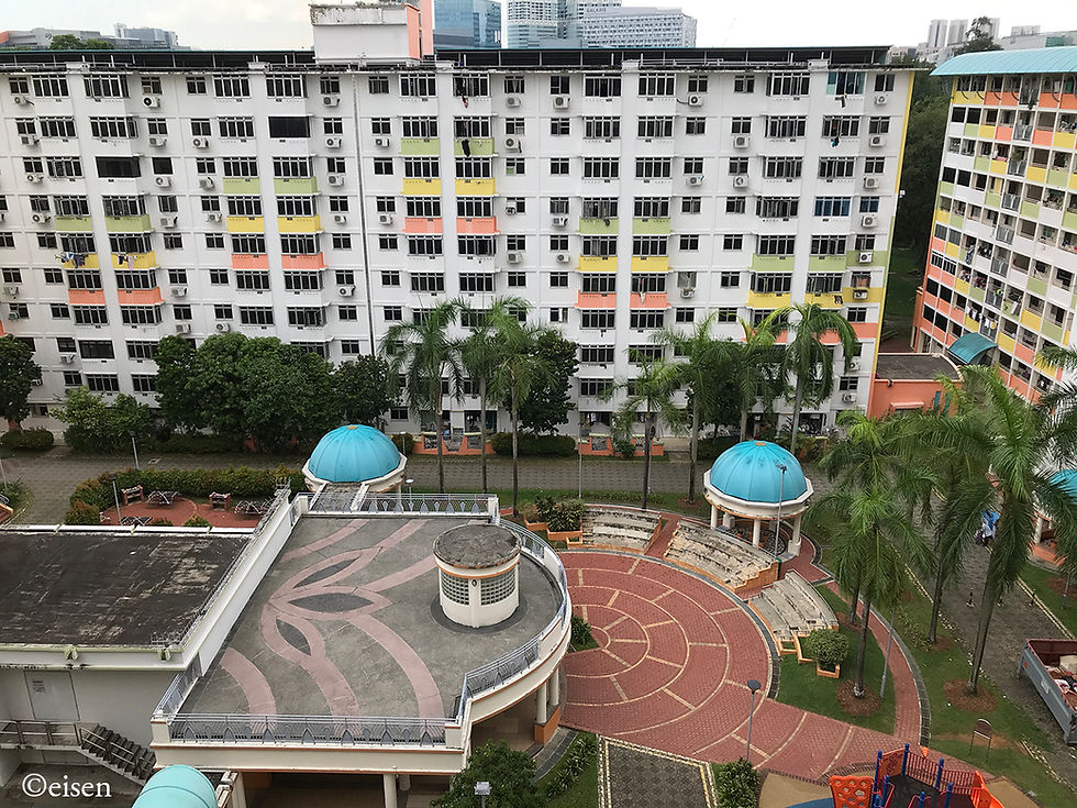
The community square, from the top floor of Block 38. I hope such openness and greenery will be retained for future developments replacing Tanglin Halt Estate.

ree

Essential services by the staircase...

ree

Lay religion for one’s home.

ree

4. Tanglin Grove


The open area between two blocks, which was a walkway with trees, grass, and space for bicycles, communal gatherings and first-floor occupants to hang their laundry. For these old blocks, the first floor also comprised flats, not void decks.

ree

The blocks in this neighbourhood have a yellowish colour scheme.

ree

Block 27, from Block 26.

ree

Block 32, 7th floor.

ree

Block 32, 9th floor.

ree

The future and the past, next to each other: Block 32 in the foreground, at just nine storeys. It was completed in 1970. Towering over it in the background is Block 90 Tanglin Halt Road, part of the neighbourhood known as Commonwealth View. It soars to 40 storeys, and was completed in 2008, 38 years after Block 32.

ree


Copyright © 2025 Eisen Teo. Proudly created with Wix.com

bottom of page